Waikouaiti River
About the catchment
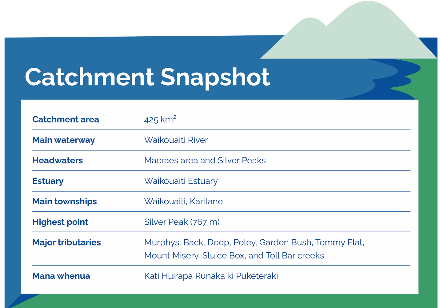
The Waikouaiti River is one of Otago's major east coast river systems, draining a 425 km² catchment north of Dunedin. The river forms where the North Branch, which rises near Macraes, meets the South Branch, which originates in the Silver Peaks Scenic Reserve. From there, it flows into the Waikouaiti Estuary before reaching the Pacific Ocean.
The lower reaches of the river are strongly influenced by tides, with tidal flows extending upstream beyond Orbells Crossing. The catchment includes a diverse landscape of floodplains, rolling hills, steeplands, and elevated plateau country.
The catchment is home to the community of Karitane. Sheep and beef farming and forestry are the dominant land uses in the catchment, with small amounts of poultry and dairy farming, and mining. Pockets of native forest are scattered throughout the catchment, with important tracts in Silver Peaks Scenic Reserve in the headwaters of the South Branch and around Hikaroroa Mt Watkin.
Freshwater values
The Waikouaiti River and Estuary support a wide range of environmental, cultural, recreational, and community values.
The river provides important habitat for several native fish species, including threatened species such as the flathead galaxiid, hybrid galaxiid, banded kōkopu, kōaro, and īnanga (whitebait). The lower reaches of the river contain important spawning habitat for īnanga, while the upper catchment supports rare freshwater invertebrates. The river also provides habitat for eel, trout, and juvenile fish.
The Waikouaiti Estuary is one of Otago’s most significant coastal wetlands and contains the largest remaining saltmarsh system in the region. It provides habitat for a variety of native plants and is an important area for coastal bird species, including eastern bar-tailed godwits and oystercatchers.
The river is also an important source of drinking water, supplying the Waikouaiti community as well as the Mt Pleasant-Stonewood scheme.
Recreation
The Waikouaiti River and Estuary are popular community spots for:
swimming at sites such as Bucklands Crossing and Karitane Wharf
trout fishing, including for sea-run brown trout in the lower river
whitebaiting during the spring season.
shellfish gathering, fishing, boating and walking around the estuary
Interactive Catchment Map
Explore our interactive mapping tool to view waterways, landforms, wetlands, and other key features across the catchment to support planning and restoration efforts. This tool has been developed by Collaborations for the East Otago Catchment Group. It's designed to support landowners and the East Otago Catchment Group in decision-making, and to provide guidance for mitigation options.
Sign up to our collective newsletter covering all the latest updates across our catchments.